The Great Bend of the Sioux River
THE GREAT BEND OF THE SIOUX RIVER
The City of Sioux Falls was first established in 1857, twenty years after George Seney explored and surveyed the area of the Big Bend, and the Falls of the Sioux River. Many of you may know of the history of the Falls, Seney Island, let alone the Rapids of the Sioux River as it passes down through the cortes de prairie, where the river begins from a marshland near Sisseton, however, what many least remember, is that the area making up Sioux Falls was known as the Great Bend of the River.
George Seney, famously remembered for his landmark discovery of what became known as Seney Island, was an early explorer, a federal land surveyor paid to go out and explore the lands purchased by the Louisiana Purchase, made by former President Thomas Jefferson in the year 1802, and later sending out an exploration team led by Merriweather Lewis, and William Clark in what became known as the Corpse of Discovery Expedition which took place between 1803 to the year 1807.
In its wake, the exploration would bring a review and audit period of what laid out across the western lands of what famously became the central plains, the great northwest, which would play a huge role in developing the continent in future years.
Shortly after they returned, another land surveyor, George Seney paid by investors of the Western Town Company set out in 1832 to explore lands which would become Dakota Territory, a group of investors from Iowa of whom wished to develop lands out west in order to lay claim to, and settle lands which would become townsites, what he discovered was an area of land near the Great Bend, a point of which the Sioux River, as it made its pathway south towards the Missouri River, however, during the last ice age, more than 15,000 years prior, due to the highlands of the cortes de prairie, much of the land forced the ice to yield, halt, which forces the river to redirect its path in an easterly fashion near what became Tut-Hill Park today, and due to the topography of the land, forces the river back to the north, to modern day Downtown Sioux Falls, where it pounded its way through a rocky, berrian terrain which led to the formation of a series of WaterFalls.
The Falls on the Big Sioux River as they became known today, were made up of a series of waterfalls that became known as the Upper Falls, the Main Falls, and the Cascade Falls, all of which were made during the most recent ice age.
In 1832 - George Seney would have arrived at this point, first landing, camping on a wooded island, above the series of falls. That island later became known as Seney Island, later Brookings Island when developer W.W Brookings purchased it in the 1870's, and later on renamed Seney Island as it was resold to a private resident in 1902.
Upon his return back to Dubuque, Iowa, the group of investors led by Joseph Nicollet, led an effort to claim land above the falls which later became the area of 3rd Street, north of 7th Street, alongside the river, and east of an area that became Maine Ave.
The Dakota Land Company led by a group of Democrats out of St. Paul, Minnesota, led by Samuel Medary, William Nobles, and Charles Flandreaux, of whom also were highly invested in a group of men who founded the Pacific Wagon Road, which led to establishing the Minnesota, Nebraska, and Pacific Mail Transportation Company, an early version of what became known as the St. Paul-Omaha-Pacific Railroad Company a few decades earlier.
While the Western Town Company had already claimed lands first, above the Falls, establishing the Village of Sioux Falls, the Dakota Land Company arrived soon after in 1857, claiming land south of 7th Street, but north of 10th Street establishing Sioux Falls City. Both land claims would have been established under the 1841 Preemption Act which allowed settlers to claim land in order to build townsites, develop the land for residential, commercial, and agriculture, with the goal of prospering from the land, in return, they would owe the federal government 20% of all profits made from the minerals and natural resources taken from the land.
The 1841 Preemption Act was the first of two settlement acts, with the 1862 Homestead Act being adopted under Abraham Lincoln during the civil war, which amended the earlier law, allowing 'pro-union' Americans to have first right to claim land. Both acts were modeled from origins of the 1777 Northwest Ordinance, which was amended once in 1790, and again in 1804, and was the early adopted plan to colonize, and settle town site claims, while adopting rules and codes as to how to plan, zone, and organize land in a square or rectangle sized area of 80, 160, or later on 320 acres of land.
While many know this area to be known for the Falls on the Big Sioux River, what many do not know is the "Big Bend of the Sioux River is really what the area is a part of, and as the river winds its way south, it was formed by the last ice age.
A highland existed along the east side of South Dakota long before the Ice Age began two million years ago. Successive periods of glaciation deposited sediment across the highland and increased its elevation. The last glaciation began 35,000 years ago during the late Wisconsin Stage. By then the highland had become a barrier that divided the ice sheet into two south-flowing lobes: the James Lobe to the west and the Des Moines Lobe to the east. When the James Lobe reached the nearby southwest corner of the highland, it turned to flow east. In time the glacier began to recede. Meltwater flowing south down the Skunk Creek and Big Sioux River valleys was dammed by the James Lobe, causing it to flow east to Tuthill Park. There it was diverted several miles north before joining the Slip-Up and Split Rock creeks and then resuming its southerly flow. In this manner the Great Bend of the Big Sioux River was created by James Lobe about 15,000 years ago. Glacial deposits overlay the flatiron-shaped highland that is now called the Coteau des Prairies.
As the river maneuvered its way through this area known as the big bend, it laid out, and allowed for several mineral deposits to become deposited in the rich soil it carved its path within. Many of these deposits were laid out between the south pathway, and its northerly pathway as it swung back, creating the falls.
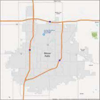
As the river wound its way from the north, much of the old river can still be seen today near Elmwood Park, Sherman Park near the Great Plains Zoo, the Minnehaha and Westward Ho Golf Courses, the area south of 41st Street as it wound its way south to what became 57th Street today - and what became Sertoma Park in the late 1990's.
As you walk the nature trails within Sertoma Park, southward near 57th Street - you will see much of the remains of the Big Bend, as the river wound its way southward, it had made a huge swooping loop to the east, then bended back to the west, where it would form a huge bend as it turned and came back to the east towards Tut-Hill Park, where the hillside forces the river to come back to the north as it carved a pathway eastern Sioux Falls to Downtown, on through what became Brandon today.
Today, what we have left over, are the Western Bluff overlooking the early townsite from above, while the Eastern Bluff overlooks the river from the eastern side, and where these two bluffs meet in the south, you end up with the region named Tut-Hill.
On the western edge of the Western Bluff in the north, you have an ancient spring, which pops up within the Industrial Park, later named a Covell Spring (or lake), which feeds on through Sandy Creek, as it leads into the Sioux River in western Sioux falls, where also you have Skunk Creek which also feeds the river, which helped form a massive rush of force as the river carved its way through the bluffs, helping to create the Falls today.
The area today between 3rd Street and north of 10th Street became the early townsites making up the Village of Sioux Falls and Sioux Falls City, both governed by "Board of Trustees" of the Western Town Company and Dakota Land Company.
A period of five years between 1866 and 1870 led to the townsites being deserted due to indian attacks, however, as the early settlers later made their way back, the two groups came together to establish the Town of Sioux Falls which later set out to platt out sections of land between 6th Street south to 12th Street laying out 36 sections of 1 acre each, with section 16 being reserved for public education, an early framework (concept) of the 1777 Northwest Ordinance.
The Town of Sioux Falls was formed in 1877 - and during the organic period between 1877 and 1899, the early development of of town buildings, homes, and commerce began to take shape, much of this townsite sits in between the two bluffs, where one could easily overlook over the town from atop the eastern or western bluff lines, of which the prairie can be seen for miles in either direction.
From its original establishment the Sioux Falls was heavily, and deeply formed in a political web of political shenanigans, scheming of which to use the land in such a manner, to profit from, take from, and to build a massive economic stronghold.
The nature of these political appointments suggests that the Big Sioux area was hardly over-run with settlers. The eight positions in Big Sioux County were held by only five men, with three of them appointed to two positions each. In Midway County, where DeWitt and Brawley held two positions each, the eight positions were filled by six men. Despite its braggadocio about occupying the Big Sioux Valley, the combined strength of the St. Paul and Dubuque groups during their first winter at Sioux Falls was only sixteen or seventeen men. But the paucity of settlers did not deter the speculators from political scheming. If anything, they were helped by the lack of local opposition. Years later, Flandrau suggested that the Dakota Land Company’s original intention was to create a situation where some of its holdings were left outside the state of Minnesota, which would give its leaders an opportunity to organize a new territory and state with such significant institutions as a capitol, a university, and a penitentiary. The political aims of the St. Paul and Dubuque groups became apparent soon after the election of October 13, 1857, in which voters of the proposed state of Minnesota approved a constitution and elected state officers. Although Congress still had to approve Minnesota’s statehood and Minnesota was not admitted to the Union until May 11, 1858, the Big Sioux promoters evidently already thought of themselves as being left out of the state. From election day on, they presumptuously referred to themselves as “the people of Dakota Territory.
This group now becomes the early movement to establish Dakota Territory, a section of land left out of the Minnesota state boundaries, and made up of parts of what later became North Dakota, South Dakota, Nebraska, Wyoming, and Montana.
The early townsite quickly became known as the region of the Big Bend of the Sioux River, quickly becoming known as the Falls of the Sioux River, quickly became the Town of Sioux Falls by 1877 and in turn, became the economic capital of Dakota Territory. Government buildings were erected, offices, land agencies, and a commercial district established.
From above, you can see how this area known as the Big Bend has laid out the foundation of how the City of Sioux Falls was to be laid out, from below the bluff lines, the early townsite was developed, and from above the bluffs, additional settlements were formed - such as West Sioux, the W.H Lyons Property, the Phillips Property or McKennan Park today, the Tuttle Family property overlooking the Sioux River in the southeast, and of course you had the groups who formed Delapre Township to the south, and Wayne Township to the west, and of course the Splitrock Township in the far east.
Collectively these settlements conservatively came together in due time, as the Town of Sioux Falls quickly expanded its borders, with much of Western Sioux Falls gaining population in the 1940's thanks to the National Air Force Training School, which would nearly double the population in a matter of a few short years to 78,000, and the townships surrounding Sioux Falls quickly gained in population, later on becoming parts of Sioux Falls today.
All these groups grew up around an area 10 miles wide, and 10 miles long, what is known as the Great Bend of the Sioux River, quickly became a large metro area today of which became the City of Sioux Falls by the year 1995 with the adoption of a newly crafted Home Rule Charter which has since connected the residents of early Sioux Falls, to those of Splitrock, Wayne, Dulapre, to parts of Mapleton Township in the north, of which today, includes the Cities of Brandon, Harrisburg, Tea, Ellis, Renner, West Sioux Falls, South Sioux Falls, and of course the legendary East Sioux Falls.
An area of which the Federal Government would soon build its massive network of Federal Highways, beginning in the 1930's with U.S Highways 16 and 77 which could next the town to Fargo in the north, Kansas City in the south, to Butte, Wyoming in the far west, and Chicago in the far east, while in the 1950's - under Eisenhower, the Inter-State System was being created, to bring in I-29 and I-90 while I-229 would become a by-pass allowing travelers to avoid the main part of the townsite, by traveling around the southern edge, mainly the Sioux River itself, while the State connected the town within the State with S.D highway 11, 38, and 42, and soon to be S.D Highway 100, otherwise known as Veterans Parkway in Sioux Falls.
The 1995 Home Rule Charter quickly formed a Strong Mayor and Strong City Council, with the goal to unite, and form new partnerships between the Residents, the Landowners, Property Holders, Land Developers, Corporate Non-Profit Partners.
The Great Bend of the Sioux River - a story, a history, and a time capsule of a mighty river that became to be known as the City of Sioux Falls, and of which has become the Economic Capital of the State of South Dakota, and the upper Midwest.
However, the rise and fall of the Dakota Land Company, may have predicted just how the political culture of Sioux Falls was to formed today, the story of the Dakota Land Company foretells and predicts just how the politics of the area was to be formed in the area today:
The Dakota Land Company’s futile effort to organize Dakota Territory failed for a variety of reasons. The first time the Dakota issue was introduced in Congress, the slavery question, which focused attention on troubles in Kansas, cooled congressional desires to consider new territories. Later, the company miscalculated the degree of support it would get from the Buchanan administration. Some company officials believed that Buchanan would personally support their organization of Dakota Territory, but they were ignorant of some territorial history.66 In 1848, when Buchanan was serving as Polk’s secretary of state, he was asked for an opinion about the co-existence of the state of Wisconsin and the territory of Wisconsin. On that occasion, he held that local officials left outside of the state retained their authority, but on the vital question of territorial officers he offered only “no opinion.” 67 Men such as Albright and Flandrau construed Buchanan’s words to mean that he recognized the continued existence of a territory after a state had been formed out of part of it. This helps to explain the perception by the Dakota Land Company that their Dakota venture was identical to the Wisconsin-Minnesota experience of a decade earlier. The Dakota Land Company was also frustrated by regional circumstances. It never recovered from the Panic of 1857 and never achieved its incorporation goal of a $400,000 capitalization. In August 1859, at the company’s third annual meeting, its secretary, Samuel Wigfall, [164] reported that the company’s balance was a paltry $25.10 and that its receipts for the past year were only $888.68.68 Without adequate capital the company tried to develop an area far removed from the edge of settlement in Minnesota. In the late 1850s, the land was occupied for only a few miles west of New Ulm. With good land available close to established Minnesota settlements, there was little inducement for pioneers to venture into the Big Sioux country. In Minnesota, and ultimately outside of it, the close identification of the Dakota Land Company with the Democratic party worked to the company’s detriment. Minnesota Republicans were prompted, in part, to oppose the company’s Dakota plans because they saw it as a Democratic scheme to benefit land speculators. Adverse publicity in Minnesota’s Republican newspapers undercut the company’s exaggerated claims about Dakota’s population. The company’s lack of integrity, which contributed to its political failure, was of its own doing. In Minnesota’s first state election, the Dakota Land Company organized precincts in mythical towns on its lands in the southwestern part of the state and peopled the towns with mythical voters, who voted almost unanimously for Democratic candidates.69 This manipulation, which was well known in Minnesota, hardly enhanced the company’s reputation. The company’s use of the same tactics in the Fuller and Kidder elections made it an easy target for critics who were well aware of the scant population in the Big Sioux area The company’s expressed interest in helping people achieve territorial status was rather hollow considering the lack of settlers on its holdings.
While the Dakota Land Company ceased to exist as a company in the 1860's - it left its mark on the political culture of the town itself, and the lasting legacy of those who made up the company can still be seen today, as we are a city made up of a progressive, democratic regimized political culture, very different than the rest of the State itself, let alone, 'we' have the lasting effects of their main core of investors, the St. Paul, Omaha, Pacific Railroad Company, of which laid out thousands of miles tracks, which has helped connect the Great Bend of the Sioux River to other parts of the State today.
The Great Bend of the Sioux River helped lead men from Minnesota, and Iowa to come to the area, highly rich in minerals, natural resources, a river made famous by the bends, let alone the Falls of which the bend created.
The men of the Western Town Company, alongside the Dakota Land Company became the Town of Sioux Falls, and through four phases of developments, the Economic Development alongside the river in 1900-1930, the Urban Renewal Development of 1960, and the Urban Capital Projects that came to be from 1965 to 1980 all came to help develop the city today, and by 1995, a newfound city was formed, as the landowners and property holders came together to form the City of Sioux Falls, quickly has engulfed the Great Bend of the Sioux River today.
Great Bends of a River are Formed
- https://cpb-us-e1.wpmucdn.com/share.nanjing-school.com/dist/5/118/files/2014/04/What-happens-on-a-river-bend-226go97.pdf